| Sarajevo's Ozren | |
|---|---|
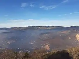 View of Sarajevo's Ozren from Trebević | |
| Highest point | |
| Elevation | 1,534 m (5,033 ft) |
| Coordinates | 43°56′01″N 18°27′02″E / 43.93361°N 18.45056°E |
| Naming | |
| Native name | Sarajevski Ozren (BCMS) |
| Geography | |
Sarajevo's Ozren is complex of mountains and hilly plateaus located northeast of Sarajevo.[1] This entire area is covered by a number of different paths and hiking trails, and it has popular picnic areas (Barice, Čavljak, Pjeskovita Ravan), popular for people from Sarajevo.[2][3]
Geography
Sarajevo's Ozren consists of several main parts:[4]
- Ozren-mountain (Ozren in the narrow sense), includes Motka, Visojevica, area Ozren-Bandijera
- Plateau Crepoljsko, includes area of Crepoljsko, area Crni Vrh (near Vučija Luka) and southeast ridges over Miljacka
- Mountain ridge Bukovik, includes main ridge Bukovik and Nahorevo hills - Bijelosava
- Hill Hum (in Sarajevo)
Highest peak of Sarajevo's Ozren is Bukovik (1534 m),[5][6] and second highest is Crepoljsko (1524 m).[7]
Skakavac waterfall, a declared natural monument is also located in Sarajevo's Ozren.
References
Wikimedia Commons has media related to Sarajevo's Ozren.
- ↑ "Sarajevo's Ozren". Sarajevo.travel.
- ↑ "Sarajevski Ozren". Sarajevo.travel.
- ↑ "Sarajevski Ozren – Mountaintour.ba".
- ↑ "Ozren (kod Sarajeva) - osnovna stranica". DINARSKO GORJE.
- ↑ "Bukovik". trail.viadinarica.com (in Bosnian).
- ↑ "PLANINE I PLANINSKI VRHOVI VIŠI OD 1500 METARA NADMORSKE VISINE". 19 April 2016. Archived from the original on 2016-04-19.
- ↑ "Crepoljsko". DINARSKO GORJE.
This article is issued from Wikipedia. The text is licensed under Creative Commons - Attribution - Sharealike. Additional terms may apply for the media files.