| Joon-Aryk | |
|---|---|
 | |
| Native name | Жоон-Арык (Kyrgyz) |
| Location | |
| Country | Kyrgyzstan |
| Region | Naryn Region |
| District | Kochkor District |
| Physical characteristics | |
| Source | confluence of Kara-Kujur and Telek |
| Mouth | Chu |
• coordinates | 42°13′15.60″N 75°44′29″E / 42.2210000°N 75.74139°E |
• elevation | 1,802 m (5,912 ft) |
| Length | 34.8 km (21.6 mi) |
| Basin size | 1,340 km2 (520 sq mi) |
| Basin features | |
| Progression | Chu→ Betpak-Dala desert |
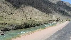
The Joon-Aryk (Kyrgyz: Жоон-Арык) is a river in Kochkor District of Naryn Region of Kyrgyzstan. It is formed by confluence of Kara-Kujur and Telek rivers. It is 34.8 kilometres (21.6 mi) long, and has a drainage basin of 1,340 square kilometres (520 sq mi).[1] Average annual discharge - 11.4 cubic meters per second. The Chu is formed by the confluence of Kochkor and Joon Aryk near the village Kochkor.[2]
References
- ↑ "Жоонарык" [Joonaryk] (PDF). Кыргызстандын Географиясы [Geography of Kyrgyzstan] (in Kyrgyz). Bishkek. 2004. pp. 185–186.
{{cite encyclopedia}}: CS1 maint: location missing publisher (link) - ↑ Иссык-Куль.Нарын:Энциклопедия [Encyclopedia of Issyk-Kul and Naryn Oblasts] (in Russian). Bishkek: Chief Editorial Board of Kyrgyz Soviet Encyclopedia. 1991. p. 512. ISBN 5-89750-009-6.
This article is issued from Wikipedia. The text is licensed under Creative Commons - Attribution - Sharealike. Additional terms may apply for the media files.