Native name: Shimoji-shima (下地島) | |
|---|---|
Shimoji Island seen from the SSE. | |
| Geography | |
| Location | Okinawa Prefecture |
| Coordinates | 24°48′58″N 125°9′25″E / 24.81611°N 125.15694°E |
| Archipelago | Miyako Islands |
| Area | 9.68 km2 (3.74 sq mi)[1] |
| Highest elevation | 21.6 m (70.9 ft) |
| Administration | |
| Prefecture | Okinawa Prefecture |
| Demographics | |
| Population | 76 (2015 national census)[1] |
| Ethnic groups | Ryukyuan, Japanese |
Shimoji-shima (下地島), (Miyako: Sïmuzï) is one of the Miyako Islands, a part of the Ryukyu Islands. The island is administered by Miyakojima, Okinawa Prefecture, Japan. The island is connected to Irabu Island via Nakaji Bridge (仲地橋).[1]
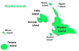
Shimoji Island is to the west of Miyako Island
Shimoji-shima is included within the Irabu Prefectural Natural Park and is the main setting for the anime series Stratos 4.
Shimojishima Airport is located on the island.
Climate
| Climate data for Shimoji-shima (2003−2020 normals, extremes 2003−present) | |||||||||||||
|---|---|---|---|---|---|---|---|---|---|---|---|---|---|
| Month | Jan | Feb | Mar | Apr | May | Jun | Jul | Aug | Sep | Oct | Nov | Dec | Year |
| Record high °C (°F) | 27.5 (81.5) |
27.5 (81.5) |
28.2 (82.8) |
29.9 (85.8) |
32.6 (90.7) |
34.2 (93.6) |
36.1 (97.0) |
35.0 (95.0) |
34.4 (93.9) |
33.6 (92.5) |
30.5 (86.9) |
28.8 (83.8) |
36.1 (97.0) |
| Mean daily maximum °C (°F) | 21.2 (70.2) |
22.1 (71.8) |
23.1 (73.6) |
25.3 (77.5) |
28.2 (82.8) |
30.4 (86.7) |
32.1 (89.8) |
31.8 (89.2) |
30.9 (87.6) |
28.7 (83.7) |
26.2 (79.2) |
22.7 (72.9) |
26.9 (80.4) |
| Daily mean °C (°F) | 18.4 (65.1) |
19.1 (66.4) |
20.1 (68.2) |
22.4 (72.3) |
25.2 (77.4) |
27.8 (82.0) |
29.1 (84.4) |
28.8 (83.8) |
27.9 (82.2) |
25.8 (78.4) |
23.4 (74.1) |
20.0 (68.0) |
24.0 (75.2) |
| Mean daily minimum °C (°F) | 15.9 (60.6) |
16.6 (61.9) |
17.4 (63.3) |
19.9 (67.8) |
22.9 (73.2) |
25.7 (78.3) |
26.8 (80.2) |
26.4 (79.5) |
25.5 (77.9) |
23.6 (74.5) |
21.2 (70.2) |
17.7 (63.9) |
21.6 (70.9) |
| Record low °C (°F) | 7.0 (44.6) |
6.8 (44.2) |
8.9 (48.0) |
11.8 (53.2) |
14.4 (57.9) |
18.7 (65.7) |
22.0 (71.6) |
23.1 (73.6) |
18.6 (65.5) |
16.5 (61.7) |
13.3 (55.9) |
7.3 (45.1) |
6.8 (44.2) |
| Average precipitation mm (inches) | 124.5 (4.90) |
103.5 (4.07) |
110.8 (4.36) |
142.2 (5.60) |
197.0 (7.76) |
192.0 (7.56) |
112.5 (4.43) |
262.2 (10.32) |
224.9 (8.85) |
130.5 (5.14) |
159.0 (6.26) |
120.8 (4.76) |
1,879.7 (74.00) |
| Average precipitation days (≥ 1.0 mm) | 12.2 | 10.7 | 9.7 | 9.3 | 10.5 | 10.2 | 8.3 | 12.1 | 10.3 | 9.3 | 11.0 | 11.6 | 125.2 |
| Source: JMA[2][3] | |||||||||||||
See also
References
- 1 2 3 "Remote island related materials (離 島 関 係 資 料)" (PDF). Archived (PDF) from the original on 2020-02-15. Retrieved 2020-02-15.
- ↑ 観測史上1~10位の値(年間を通じての値). JMA. Retrieved February 24, 2022.
- ↑ 気象庁 / 平年値(年・月ごとの値). JMA. Retrieved February 24, 2022.
| Core city | ||
|---|---|---|
| Cities | ||
| Districts | ||
24°49′08″N 125°09′14″E / 24.819°N 125.154°E
This article is issued from Wikipedia. The text is licensed under Creative Commons - Attribution - Sharealike. Additional terms may apply for the media files.