| Tosa d'Alp | |
|---|---|
 | |
| Highest point | |
| Elevation | 2,587 m (8,488 ft) |
| Prominence | 806 m (2,644 ft) |
| Isolation | 14.23 km (8.84 mi) to Comabona |
| Listing | List of mountains in Catalonia |
| Coordinates | 42°19′18.02″N 1°53′37.75″E / 42.3216722°N 1.8938194°E |
| Naming | |
| Language of name | Catalan |
| Geography | |
| Location | Baixa Cerdanya |
| Parent range | Pyrenees |
| Climbing | |
| Easiest route | Climb |
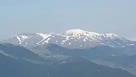
Tosa d'Alp or La Tosa is a 2,587-metre-high (8,488 ft) mountain in Baixa Cerdanya in the Spanish Pyrenees.[1] The Coll de Pal is a mountain pass that separates its eastern part from the Puigllançada. This mountain forms a quadripoint where the Alp, Urús, Das and Bagà municipal limits meet. There is a triangulation station (282081001) at the summit.
Part of its slopes are home to the ski resort of Masella which is part of Alp 2500.[2]
References
- ↑ "Mapa Topogràfic de Catalunya". Institut Cartogràfic de Catalunya. Archived from the original on 19 June 2010. Retrieved May 22, 2010.
- ↑ Masella ski resort
This article is issued from Wikipedia. The text is licensed under Creative Commons - Attribution - Sharealike. Additional terms may apply for the media files.