Bache, Oklahoma | |
|---|---|
 Bache, Oklahoma  Bache, Oklahoma | |
| Coordinates: 34°53′39″N 95°39′02″W / 34.89417°N 95.65056°W | |
| Country | United States |
| State | Oklahoma |
| County | Pittsburg |
| Area | |
| • Total | 0.32 sq mi (0.83 km2) |
| • Land | 0.32 sq mi (0.83 km2) |
| • Water | 0.00 sq mi (0.00 km2) |
| Elevation | 755 ft (230 m) |
| Population (2020) | |
| • Total | 105 |
| • Density | 326.09/sq mi (125.86/km2) |
| Time zone | UTC-6 (Central (CST)) |
| • Summer (DST) | UTC-5 (CDT) |
| Area codes | 918 & 539 |
| GNIS feature ID | 2629905[2] |
Bache is an unincorporated community in Pittsburg County, Oklahoma, United States.[2] The community is located on U.S. Route 270, 7 miles (11 km) east of McAlester.
A post office was established at Bache, Indian Territory on February 26, 1903. It closed on July 29, 1995.[3]
At the time of its founding, the community was located in the Moshulatubbee District of the Choctaw Nation.[4] The community was named for mining operator Franklin Bache.[5]
Demographics
| Census | Pop. | Note | %± |
|---|---|---|---|
| 2020 | 105 | — | |
| U.S. Decennial Census[6] | |||
References
- ↑ "ArcGIS REST Services Directory". United States Census Bureau. Retrieved September 20, 2022.
- 1 2 3 U.S. Geological Survey Geographic Names Information System: Bache, Oklahoma
- ↑ "Postmaster Finder - Post Offices by ZIP Code". United States Postal Service. Archived from the original on October 17, 2020. Retrieved October 17, 2016.
- ↑ Morris, John W. Historical Atlas of Oklahoma (Norman: University of Oklahoma Press, 1986), plate 38.
- ↑ Shirk, George H. (1974). Oklahoma Place Names (2 ed.). Norman, Oklahoma: University of Oklahoma Press. p. 15. ISBN 0806111402.
- ↑ "Census of Population and Housing". Census.gov. Retrieved June 4, 2016.
Municipalities and communities of Pittsburg County, Oklahoma, United States | ||
|---|---|---|
| Cities | 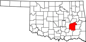 Pittsburg County map | |
| Towns | ||
| CDPs | ||
| Other communities | ||
| Indian reservation | ||
| Footnotes | ‡This populated place also has portions in another county or counties | |
This article is issued from Wikipedia. The text is licensed under Creative Commons - Attribution - Sharealike. Additional terms may apply for the media files.