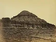
The Church Buttes is an eroded sandstone butte formation in Uinta County, Wyoming. It is notable for its prehistorical archaeological remains as well as being the location a camp site for the first party of Mormon leader Brigham Young, July 7, 1847.[1] It was the site of one of the relays for the pony express.[2]
The U.S. Geographic Names Information System identifies another Church Butte in Sweetwater County, Wyoming.[3]
Climate
According to the Köppen Climate Classification system, the area has a cold semi-arid climate, abbreviated "BSk" on climate maps. The hottest temperature recorded at the Church Buttes Gas Plant was 100 °F (37.8 °C) on June 24, 1985, while the coldest temperature recorded was −40 °F (−40.0 °C) on December 21, 1990.[4]
| Climate data for Church Battles Gas Plant, Wyoming, 1991–2020 normals, extremes 1955–present | |||||||||||||
|---|---|---|---|---|---|---|---|---|---|---|---|---|---|
| Month | Jan | Feb | Mar | Apr | May | Jun | Jul | Aug | Sep | Oct | Nov | Dec | Year |
| Record high °F (°C) | 54 (12) |
58 (14) |
71 (22) |
80 (27) |
89 (32) |
100 (38) |
98 (37) |
98 (37) |
94 (34) |
82 (28) |
67 (19) |
60 (16) |
100 (38) |
| Mean maximum °F (°C) | 44.9 (7.2) |
47.2 (8.4) |
58.7 (14.8) |
69.7 (20.9) |
78.5 (25.8) |
87.2 (30.7) |
91.5 (33.1) |
89.4 (31.9) |
83.4 (28.6) |
73.0 (22.8) |
58.4 (14.7) |
46.3 (7.9) |
92.1 (33.4) |
| Mean daily maximum °F (°C) | 31.2 (−0.4) |
32.7 (0.4) |
43.3 (6.3) |
52.2 (11.2) |
63.3 (17.4) |
75.2 (24.0) |
83.4 (28.6) |
81.3 (27.4) |
71.3 (21.8) |
56.9 (13.8) |
41.2 (5.1) |
31.4 (−0.3) |
55.3 (12.9) |
| Daily mean °F (°C) | 21.9 (−5.6) |
22.9 (−5.1) |
33.0 (0.6) |
39.9 (4.4) |
50.2 (10.1) |
60.7 (15.9) |
69.0 (20.6) |
67.1 (19.5) |
57.4 (14.1) |
44.1 (6.7) |
31.0 (−0.6) |
21.8 (−5.7) |
43.2 (6.2) |
| Mean daily minimum °F (°C) | 12.5 (−10.8) |
13.1 (−10.5) |
22.6 (−5.2) |
27.6 (−2.4) |
37.1 (2.8) |
46.3 (7.9) |
54.5 (12.5) |
52.8 (11.6) |
43.5 (6.4) |
31.2 (−0.4) |
20.8 (−6.2) |
12.2 (−11.0) |
31.2 (−0.4) |
| Mean minimum °F (°C) | −5.5 (−20.8) |
−3.3 (−19.6) |
7.1 (−13.8) |
15.9 (−8.9) |
24.8 (−4.0) |
34.3 (1.3) |
45.0 (7.2) |
42.8 (6.0) |
30.0 (−1.1) |
14.9 (−9.5) |
2.4 (−16.4) |
−4.3 (−20.2) |
−11.2 (−24.0) |
| Record low °F (°C) | −35 (−37) |
−35 (−37) |
−15 (−26) |
−2 (−19) |
11 (−12) |
25 (−4) |
30 (−1) |
29 (−2) |
5 (−15) |
−19 (−28) |
−16 (−27) |
−40 (−40) |
−40 (−40) |
| Average precipitation inches (mm) | 0.53 (13) |
0.35 (8.9) |
0.48 (12) |
0.79 (20) |
1.21 (31) |
0.86 (22) |
0.42 (11) |
0.70 (18) |
1.09 (28) |
0.73 (19) |
0.47 (12) |
0.24 (6.1) |
7.87 (201) |
| Average snowfall inches (cm) | 6.9 (18) |
4.7 (12) |
4.1 (10) |
2.3 (5.8) |
1.1 (2.8) |
0.0 (0.0) |
0.0 (0.0) |
0.0 (0.0) |
0.3 (0.76) |
1.1 (2.8) |
5.6 (14) |
4.7 (12) |
30.8 (78.16) |
| Average precipitation days (≥ 0.01 in) | 3.5 | 3.1 | 3.5 | 4.4 | 5.6 | 4.0 | 2.9 | 4.1 | 3.9 | 3.7 | 3.5 | 3.6 | 45.8 |
| Average snowy days (≥ 0.1 in) | 3.0 | 2.5 | 2.6 | 1.2 | 0.5 | 0.0 | 0.0 | 0.0 | 0.1 | 0.7 | 2.4 | 2.4 | 15.4 |
| Source 1: NOAA[5] | |||||||||||||
| Source 2: National Weather Service[4] | |||||||||||||
References
- ↑ Federal Writers Project (1941), Wyoming: A Guide to Its History, Highways, and People, American guide series, North American Book Dist LLC, p. 261, ISBN 0403021995.
- ↑ Guthrie, Carol; Smith, Bart (2009), The Pony Express: An Illustrated History, Two Dot Series, Globe Pequot, p. 90, ISBN 0762748168.
- ↑ "Church Butte". Geographic Names Information System. United States Geological Survey. Retrieved 2013-12-31.
- 1 2 "NOAA Online Weather Data – NWS Salt Lake City". National Weather Service. Retrieved April 10, 2023.
- ↑ "U.S. Climate Normals Quick Access – Station: Church Buttes Gas PLT, WY". National Oceanic and Atmospheric Administration. Retrieved April 10, 2023.
External links
- Walsh, Dave (July 13, 2012), "Church Buttes", Wonders of Wyoming, retrieved 2012-08-17
- "Church Butte". Geographic Names Information System. United States Geological Survey. Retrieved 2013-12-31.
41°30′20″N 110°08′06″W / 41.50551°N 110.13487°W