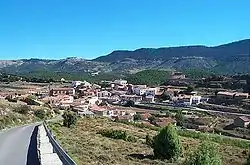
El Castellar | |
|---|---|
 | |
 Flag  Seal | |
 | |
| Coordinates: 40°22′N 0°49′W / 40.367°N 0.817°W | |
| Country | Spain |
| Autonomous community | Aragon |
| Province | Teruel |
| Comarca | Gúdar-Javalambre |
| Area | |
| • Total | 50.33 km2 (19.43 sq mi) |
| Population (2018)[1] | |
| • Total | 52 |
| • Density | 1.0/km2 (2.7/sq mi) |
| Time zone | UTC+1 (CET) |
| • Summer (DST) | UTC+2 (CEST) |
El Castellar is a municipality located in the province of Teruel, Aragon, Spain. According to the 2004 census (INE), the municipality had a population of 81 inhabitants.
References
- ↑ Municipal Register of Spain 2018. National Statistics Institute.
This article is issued from Wikipedia. The text is licensed under Creative Commons - Attribution - Sharealike. Additional terms may apply for the media files.