Fourmetot | |
|---|---|
Part of Le Perrey | |
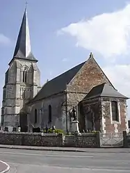 The church in Fourmetot | |
Location of Fourmetot | |
 Fourmetot 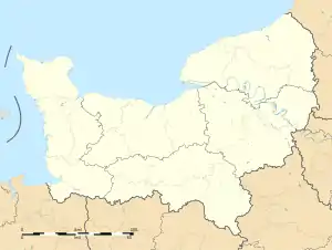 Fourmetot | |
| Coordinates: 49°22′56″N 0°34′22″E / 49.3822°N 0.5728°E | |
| Country | France |
| Region | Normandy |
| Department | Eure |
| Arrondissement | Bernay |
| Canton | Pont-Audemer |
| Commune | Le Perrey |
| Area 1 | 10.02 km2 (3.87 sq mi) |
| Population (2019)[1] | 709 |
| • Density | 71/km2 (180/sq mi) |
| Time zone | UTC+01:00 (CET) |
| • Summer (DST) | UTC+02:00 (CEST) |
| Postal code | 27500 |
| Elevation | 48–134 m (157–440 ft) (avg. 127 m or 417 ft) |
| 1 French Land Register data, which excludes lakes, ponds, glaciers > 1 km2 (0.386 sq mi or 247 acres) and river estuaries. | |
Fourmetot (French pronunciation: [fuʁməto]) is a former commune in the Eure department in the Normandy region in northern France. On 1 January 2019, it was merged into the new commune Le Perrey.[2]
Population
| Year | Pop. | ±% |
|---|---|---|
| 1962 | 327 | — |
| 1968 | 384 | +17.4% |
| 1975 | 386 | +0.5% |
| 1982 | 434 | +12.4% |
| 1990 | 520 | +19.8% |
| 1999 | 552 | +6.2% |
| 2008 | 644 | +16.7% |
See also
References
- ↑ Téléchargement du fichier d'ensemble des populations légales en 2019, INSEE
- ↑ Arrêté préfectoral 21 December 2018 (in French)
External links
Wikimedia Commons has media related to Fourmetot.
This article is issued from Wikipedia. The text is licensed under Creative Commons - Attribution - Sharealike. Additional terms may apply for the media files.