Gaudiempré | |
|---|---|
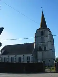 The church of Gaudiempré | |
 Coat of arms | |
Location of Gaudiempré | |
 Gaudiempré 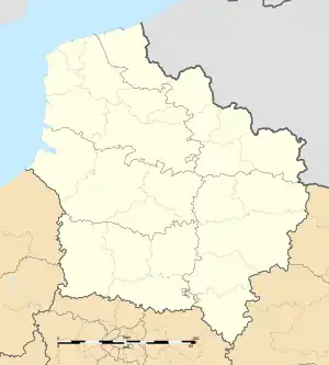 Gaudiempré | |
| Coordinates: 50°10′43″N 2°31′52″E / 50.1786°N 2.5311°E | |
| Country | France |
| Region | Hauts-de-France |
| Department | Pas-de-Calais |
| Arrondissement | Arras |
| Canton | Avesnes-le-Comte |
| Intercommunality | CC Campagnes de l'Artois |
| Government | |
| • Mayor (2020–2026) | Luc Delaporte[1] |
| Area 1 | 6.26 km2 (2.42 sq mi) |
| Population | 212 |
| • Density | 34/km2 (88/sq mi) |
| Time zone | UTC+01:00 (CET) |
| • Summer (DST) | UTC+02:00 (CEST) |
| INSEE/Postal code | 62368 /62760 |
| Elevation | 114–169 m (374–554 ft) (avg. 158 m or 518 ft) |
| 1 French Land Register data, which excludes lakes, ponds, glaciers > 1 km2 (0.386 sq mi or 247 acres) and river estuaries. | |
Gaudiempré is a commune in the Pas-de-Calais department in the Hauts-de-France region of France.[3]
Geography
Gaudiempré is a small farming village situated 14 miles (23 km) southwest of Arras, at the junction of the D23 and the D1 roads.
Population
| Year | Pop. | ±% p.a. |
|---|---|---|
| 1968 | 263 | — |
| 1975 | 225 | −2.20% |
| 1982 | 205 | −1.32% |
| 1990 | 182 | −1.48% |
| 1999 | 187 | +0.30% |
| 2007 | 177 | −0.68% |
| 2012 | 190 | +1.43% |
| 2017 | 199 | +0.93% |
| Source: INSEE[4] | ||
Places of interest
- The church of St.Nicholas, dating from the seventeenth century.
See also
References
- ↑ "Répertoire national des élus: les maires". data.gouv.fr, Plateforme ouverte des données publiques françaises (in French). 9 August 2021.
- ↑ "Populations légales 2021". The National Institute of Statistics and Economic Studies. 28 December 2023.
- ↑ INSEE commune file
- ↑ Population en historique depuis 1968, INSEE
Wikimedia Commons has media related to Gaudiempré.
This article is issued from Wikipedia. The text is licensed under Creative Commons - Attribution - Sharealike. Additional terms may apply for the media files.