Geisenfeld | |
|---|---|
 Coat of arms | |
Location of Geisenfeld within Pfaffenhofen an der Ilm district 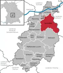 | |
 Geisenfeld  Geisenfeld | |
| Coordinates: 48°40′N 11°36′E / 48.667°N 11.600°E | |
| Country | Germany |
| State | Bavaria |
| Admin. region | Oberbayern |
| District | Pfaffenhofen an der Ilm |
| Municipal assoc. | Geisenfeld |
| Subdivisions | 12 Ortsteile |
| Government | |
| • Mayor (2020–26) | Paul Weber[1] |
| Area | |
| • Total | 88.33 km2 (34.10 sq mi) |
| Elevation | 385 m (1,263 ft) |
| Population (2022-12-31)[2] | |
| • Total | 11,605 |
| • Density | 130/km2 (340/sq mi) |
| Time zone | UTC+01:00 (CET) |
| • Summer (DST) | UTC+02:00 (CEST) |
| Postal codes | 85290 |
| Dialling codes | 08452 |
| Vehicle registration | PAF |
| Website | www.geisenfeld.de |
Geisenfeld is a town in the district of Pfaffenhofen, in Bavaria, Germany. It is situated on the river Ilm, 16 km (9.94 mi) southeast of Ingolstadt. The town grew up around Geisenfeld Abbey, a convent founded in 1037.
Subdivisions
Geisenfeld has twelve districts, formerly independent municipalities:
- Engelbrechtsmünster
- Gaden including Wasenstadt and Furthof
- Geisenfeld
- Geisenfeldwinden
- Ilmendorf including Einberg
- Nötting
- Parleiten including Eichelberg, Holzleiten and Scheuerhof
- Rottenegg including Hornlohe, Moosmühle and Brunn
- Schillwitzried including Schillwitzhausen, Schafhof and Gießübel
- Untermettenbach including Obermettenbach and Ziegelstadel
- Unterpindhart including Kolmhof, Untereulenthal and Obereulenthal
- Zell including Ainau, Ritterswörth, Unterzell and Oberzell
Sons and daughters of the town
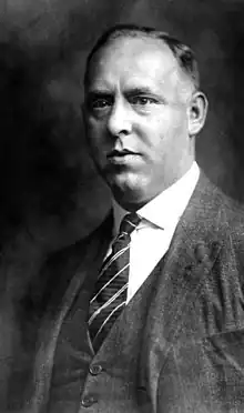
Gregor Strasser 1928
- Gregor Strasser (1892-1934), national socialist politician, publisher and participant in Hitler-Ludendorff-Putsch
References
- ↑ Liste der ersten Bürgermeister/Oberbürgermeister in kreisangehörigen Gemeinden, Bayerisches Landesamt für Statistik, 15 July 2021.
- ↑ Genesis Online-Datenbank des Bayerischen Landesamtes für Statistik Tabelle 12411-003r Fortschreibung des Bevölkerungsstandes: Gemeinden, Stichtag (Einwohnerzahlen auf Grundlage des Zensus 2011)
Towns and municipalities in Pfaffenhofen (district) | ||
|---|---|---|
This article is issued from Wikipedia. The text is licensed under Creative Commons - Attribution - Sharealike. Additional terms may apply for the media files.