Godfrey, Kansas | |
|---|---|
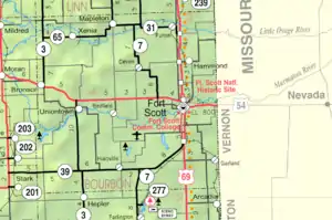 KDOT map of Bourbon County (legend) | |
| Coordinates: 37°45′42″N 94°42′36″W / 37.76167°N 94.71000°W[1] | |
| Country | United States |
| State | Kansas |
| County | Bourbon |
| Platted | 1871 |
| Elevation | 961 ft (293 m) |
| Time zone | UTC-6 (CST) |
| • Summer (DST) | UTC-5 (CDT) |
| Area code | 620 |
| FIPS code | 20-26735 |
| GNIS ID | 484699[1] |
Godfrey is an unincorporated community in Bourbon County, Kansas, United States.[1]
History
Godfrey was platted in 1871 as a coal mining community.[2] Godfrey had a post office from 1870 until 1901.[3]
References
- 1 2 3 4 U.S. Geological Survey Geographic Names Information System: Godfrey, Kansas
- ↑ "Many Towns Have Disappeared". The Fort Scott Tribune. July 16, 1976. pp. 2C. Retrieved May 16, 2015.
- ↑ "Kansas Post Offices, 1828-1961". Kansas Historical Society. Retrieved August 2, 2014.
Further reading
External links
Municipalities and communities of Bourbon County, Kansas, United States | ||
|---|---|---|
| Cities | 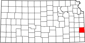 Map of Kansas highlighting Bourbon County | |
| Unincorporated communities | ||
| Townships | ||
| Footnotes | †This community is designated a Census-Designated Place (CDP) by the United States Census Bureau. ‡This community also has portions in an adjacent county or counties. | |
This article is issued from Wikipedia. The text is licensed under Creative Commons - Attribution - Sharealike. Additional terms may apply for the media files.