Hohenems-Dornbirn Airfield Flugplatz Hohenems-Dornbirn | |||||||||||
|---|---|---|---|---|---|---|---|---|---|---|---|
 | |||||||||||
| Summary | |||||||||||
| Airport type | Public | ||||||||||
| Serves | Dornbirn, Austria | ||||||||||
| Elevation AMSL | 1,352 ft / 412 m | ||||||||||
| Coordinates | 47°23′4.3″N 009°41′59.2″E / 47.384528°N 9.699778°E | ||||||||||
| Map | |||||||||||
 LOIH Location of Hohenems-Dornbirn Airfield in Austria | |||||||||||
| Runways | |||||||||||
| |||||||||||
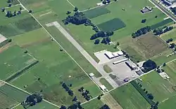
Hohenems-Dornbirn Airfield (German: Flugplatz Hohenems-Dornbirn, IATA: HOH, ICAO: LOIH) is a public aerodrome located 5 kilometres (3 mi) southwest of Dornbirn, Vorarlberg, Austria. It is used for general aviation as well as air police and air rescue operations.
See also
References
- ↑ Airport record for Hohenems-Dornbirn Airport at Landings.com. Retrieved 2013-09-01
- ↑ Google (2013-09-01). "location of Hohenems-Dornbirn Airport" (Map). Google Maps. Google. Retrieved 2013-09-01.
External links
![]() Media related to Hohenems Dornbirn Airfield at Wikimedia Commons
Media related to Hohenems Dornbirn Airfield at Wikimedia Commons
This article is issued from Wikipedia. The text is licensed under Creative Commons - Attribution - Sharealike. Additional terms may apply for the media files.