Holmes City | |
|---|---|
 Holmes City  Holmes City | |
| Coordinates: 45°50′01″N 95°32′28″W / 45.83361°N 95.54111°W | |
| Country | United States |
| State | Minnesota |
| County | Douglas |
| Elevation | 1,388 ft (423 m) |
| Time zone | UTC-6 (Central (CST)) |
| • Summer (DST) | UTC-5 (CDT) |
| ZIP code | 56341 |
| Area code | 320 |
| GNIS feature ID | 645100[1] |
Holmes City is an unincorporated community in Douglas County, Minnesota, United States. Holmes City is 9 miles (14 km) southwest of Alexandria. Holmes City has a post office with ZIP code 56341.[2]
A post office called Holmes City has been in operation since 1868.[3] The community was named for Thomas Andrew Holmes, a pioneer settler.[4]
References
- ↑ "US Board on Geographic Names". United States Geological Survey. October 25, 2007. Retrieved January 31, 2008.
- ↑ ZIP Code Lookup
- ↑ "Douglas County". Jim Forte Postal History. Retrieved May 20, 2015.
- ↑ Upham, Warren (1920). Minnesota Geographic Names: Their Origin and Historic Significance. Minnesota Historical Society. p. 177.
Municipalities and communities of Douglas County, Minnesota, United States | ||
|---|---|---|
| Cities | 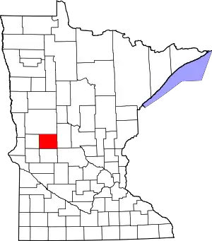 Map of Minnesota highlighting Douglas County | |
| Townships | ||
| Unincorporated communities | ||
| Footnotes | ‡This populated place also has portions in an adjacent county or counties | |
This article is issued from Wikipedia. The text is licensed under Creative Commons - Attribution - Sharealike. Additional terms may apply for the media files.