Jefferson, Kansas | |
|---|---|
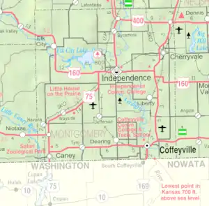 KDOT map of Montgomery County (legend) | |
 Jefferson  Jefferson | |
| Coordinates: 37°06′44″N 95°45′41″W / 37.11222°N 95.76139°W[1] | |
| Country | United States |
| State | Kansas |
| County | Montgomery |
| Founded | 1886 |
| Platted | 1886 |
| Named for | Albert Jefferson Broadbent |
| Elevation | 807 ft (246 m) |
| Time zone | UTC-6 (CST) |
| • Summer (DST) | UTC-5 (CDT) |
| Area code | 620 |
| FIPS code | 20-35275 |
| GNIS ID | 469241 [1] |
Jefferson is an unincorporated community in Montgomery County, Kansas, United States.[1]
History
Jefferson was laid out in 1886 when the railroad was extended to that point. It was named for Albert Jefferson Broadbent, the original owner of the town site.[2]
A post office was opened in Jefferson in 1888, and remained in operation until it was discontinued in 1954.[3]
Currenty, only a small general store is located here, and less than a dozen houses. Nearby is a guest ranch with an RV park.
References
- 1 2 3 4 U.S. Geological Survey Geographic Names Information System: Jefferson, Kansas
- ↑ Duncan, L. Wallace (1903). History of Montgomery County, Kansas. Press of Iola Register. pp. 81.
- ↑ "Kansas Post Offices, 1828-1961". Kansas Historical Society. Retrieved June 16, 2014.
Further reading
External links
Municipalities and communities of Montgomery County, Kansas, United States | ||
|---|---|---|
| Cities | 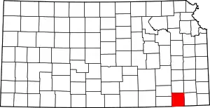 Map of Kansas highlighting Montgomery County | |
| Unincorporated communities | ||
| Ghost towns | ||
| Footnotes | †This community is designated a Census-Designated Place (CDP) by the United States Census Bureau. | |
This article is issued from Wikipedia. The text is licensed under Creative Commons - Attribution - Sharealike. Additional terms may apply for the media files.