| Kühgundkopf | |
|---|---|
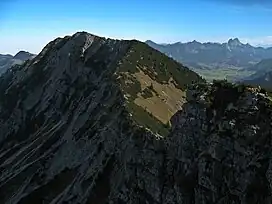 Taken from Iseler, with Tannheimer Valley | |
| Highest point | |
| Elevation | 1,907 m (6,257 ft) |
| Prominence | 287 m (942 ft) |
| Isolation | 1.6 km (0.99 mi) |
| Coordinates | 47°30′12.6″N 10°25′53.4″E / 47.503500°N 10.431500°E |
| Geography | |
| Parent range | Allgäu Alps |
Kühgundkopf is a 1907-meter mountain[1] in the Allgäu Alps of Bavaria, Germany near Reutte, Tyrol, Austria.[1] The Kühgundspitze is a rock head with cross in the Northeast part of the mountain of the Tannheimer Tal pull off.[2]
References
- 1 2 "Kuhgundkopf". peakery.com. Retrieved 2016-12-28.
- ↑ Steiner, Thaddäus (2008). Allgäuer Bergnamen. Lindenberg: Kunstverlag Josef Fink. p. 128. ISBN 9783898703895.
This article is issued from Wikipedia. The text is licensed under Creative Commons - Attribution - Sharealike. Additional terms may apply for the media files.