Laverlochère-Angliers | |
|---|---|
 | |
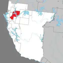 Location within Témiscamingue RCM | |
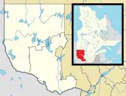 Laverlochère-Angliers Location in western Quebec | |
| Coordinates: 47°26′N 79°18′W / 47.433°N 79.300°W | |
| Country | Canada |
| Province | Quebec |
| Region | Abitibi-Témiscamingue |
| RCM | Témiscamingue |
| Constituted | January 1, 2018 |
| Named for | Jean-Nicolas Laverlochère and Angliers[1] |
| Government | |
| • Mayor | Daniel Barrette |
| • Federal riding | Abitibi—Témiscamingue |
| • Prov. riding | Rouyn-Noranda–Témiscamingue |
| Area | |
| • Total | 491.32 km2 (189.70 sq mi) |
| • Land | 400.83 km2 (154.76 sq mi) |
| Population (2021)[3] | |
| • Total | 947 |
| • Density | 2.4/km2 (6/sq mi) |
| • Pop (2016-21) | |
| • Dwellings | 525 |
| Time zone | UTC−05:00 (EST) |
| • Summer (DST) | UTC−04:00 (EDT) |
| Postal code(s) | |
| Area code | 819 |
| Highways | |
| Website | www |
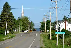
Laverlochère-Angliers is a municipality in northwestern Quebec, Canada, in the Témiscamingue Regional County Municipality. It was incorporated as a municipality on January 1, 2018, through the amalgamation of the Municipality of Laverlochère and the Village of Angliers.[4]
Demographics
In the 2016 Census of Population conducted by Statistics Canada, the former Village of Angliers recorded a population of 303 living in 139 of its 218 total private dwellings, a 1.7% change from its 2011 population of 298. With a land area of 298.21 km2 (115.14 sq mi), it had a population density of 1.0/km2 (2.6/sq mi) in 2016.[5]
Also in 2016, the former Municipality of Laverlochère recorded a population of 675 living in 289 of its 321 total private dwellings, a -7.7% change from its 2011 population of 731. With a land area of 105.08 km2 (40.57 sq mi), it had a population density of 6.4/km2 (16.6/sq mi) in 2016.[5]
Combined, the amalgamated Municipality of Laverlochère-Angliers has a population of 947 living in 443 of its 525 total private dwellings as of 2021, a -3.2% change from its 2016 population of 987. With a land area of 400.83 km2 (154.76 sq mi), it had a population density of 2.4/km2 (6.1/sq mi) in 2021.[3]
| 2021 | |
|---|---|
| Population | 947 (-3.2% from 2016) |
| Land area | 400.83 km2 (154.76 sq mi) |
| Population density | 2.4/km2 (6.2/sq mi) |
| Median age | 46.8 (M: 46.4, F: 47.2) |
| Private dwellings | 525 (total) 443 (occupied) |
| Median household income | $69,000 |
|
| ||||||||||||||||||||||||||||||||||||
| Population amounts prior to 2018 are total of Angliers (Village) and Laverlochère (Municipality). Source: Statistics Canada | |||||||||||||||||||||||||||||||||||||
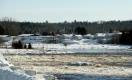 Ottawa River at the outlet of Lac des Quinze in Angliers
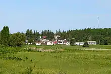 Housing in Laverlochère
Local government
List of former mayors since formation:
- Daniel Barrette (2018–present)
See also
References
- ↑ "Fiche descriptive".
- 1 2 "Répertoire des municipalités: Geographic code 85052". www.mamh.gouv.qc.ca (in French). Ministère des Affaires municipales et de l'Habitation.
- 1 2 3 "Laverlochère-Angliers, Municipalité (MÉ) Quebec [Census subdivision], Census Profile, 2021 Census of Population". www12.statcan.gc.ca. Government of Canada - Statistics Canada. 14 July 2022.
- ↑ "Gazette Officielle du Québec, December 27, 2017, Vol. 149, No. 52" (PDF). Québec Official Publisher. December 27, 2017. pp. 3877–3880. Retrieved September 29, 2019.
- 1 2 3 "2021 Community Profiles". 2021 Canadian Census. Statistics Canada. February 4, 2022. Retrieved 2023-11-27.
- ↑ "2006 Community Profiles". 2006 Canadian Census. Statistics Canada. August 20, 2019.
- ↑ "2001 Community Profiles". 2001 Canadian Census. Statistics Canada. July 18, 2021.
External links
Adjacent Municipal Subdivisions | ||||||||||||||||
|---|---|---|---|---|---|---|---|---|---|---|---|---|---|---|---|---|
| ||||||||||||||||
| Cities | |
|---|---|
| Municipalities | |
| Townships |
|
| Parishes | |
| Unorganized territories | |
| |