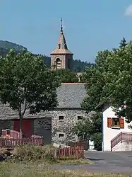
Les Estables | |
|---|---|
Commune | |
 | |
Location of Les Estables | |
 Les Estables 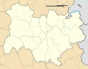 Les Estables | |
| Coordinates: 44°54′19″N 4°09′18″E / 44.9053°N 4.155°E | |
| Country | France |
| Region | Auvergne-Rhône-Alpes |
| Department | Haute-Loire |
| Arrondissement | Le Puy-en-Velay |
| Canton | Mézenc |
| Government | |
| • Mayor (2020–2026) | Philippe Brun[1] |
| Area 1 | 33.94 km2 (13.10 sq mi) |
| Population | 321 |
| • Density | 9.5/km2 (24/sq mi) |
| Time zone | UTC+01:00 (CET) |
| • Summer (DST) | UTC+02:00 (CEST) |
| INSEE/Postal code | 43091 /43150 |
| Elevation | 1,033–1,725 m (3,389–5,659 ft) (avg. 1,346 m or 4,416 ft) |
| 1 French Land Register data, which excludes lakes, ponds, glaciers > 1 km2 (0.386 sq mi or 247 acres) and river estuaries. | |
Les Estables (French pronunciation: [le.z‿ɛstabl]; Occitan: Los Estables) is a commune in the Haute-Loire department in south-central France. The area is known for its ski resorts and outdoor activities.[3]
History
A young geometer, who was doing survey work in the area for the Cassini maps, the first modern maps of France, was hacked to death by suspicious villagers in the 1740s.[4]
Population
| Year | Pop. | ±% p.a. |
|---|---|---|
| 1968 | 526 | — |
| 1975 | 480 | −1.30% |
| 1982 | 350 | −4.41% |
| 1990 | 312 | −1.43% |
| 1999 | 325 | +0.45% |
| 2009 | 355 | +0.89% |
| 2014 | 334 | −1.21% |
| 2020 | 319 | −0.76% |
| Source: INSEE[5] | ||
Climate
| Climate data for Les Estables, 1350m (1991−2020 normals) | |||||||||||||
|---|---|---|---|---|---|---|---|---|---|---|---|---|---|
| Month | Jan | Feb | Mar | Apr | May | Jun | Jul | Aug | Sep | Oct | Nov | Dec | Year |
| Mean daily maximum °C (°F) | 1.9 (35.4) |
1.8 (35.2) |
6.0 (42.8) |
10.0 (50.0) |
12.7 (54.9) |
17.8 (64.0) |
20.9 (69.6) |
20.8 (69.4) |
16.6 (61.9) |
11.7 (53.1) |
6.4 (43.5) |
3.7 (38.7) |
10.9 (51.5) |
| Daily mean °C (°F) | −0.9 (30.4) |
−1.3 (29.7) |
2.4 (36.3) |
5.8 (42.4) |
8.4 (47.1) |
13.0 (55.4) |
15.6 (60.1) |
15.4 (59.7) |
11.8 (53.2) |
8.0 (46.4) |
3.5 (38.3) |
0.7 (33.3) |
6.9 (44.4) |
| Mean daily minimum °C (°F) | −3.7 (25.3) |
−4.3 (24.3) |
−1.2 (29.8) |
1.6 (34.9) |
4.1 (39.4) |
8.1 (46.6) |
10.3 (50.5) |
10.1 (50.2) |
7.0 (44.6) |
4.2 (39.6) |
0.6 (33.1) |
−2.2 (28.0) |
2.9 (37.2) |
| Average precipitation mm (inches) | 83.9 (3.30) |
65.5 (2.58) |
91.0 (3.58) |
99.9 (3.93) |
122.6 (4.83) |
109.5 (4.31) |
93.7 (3.69) |
60.5 (2.38) |
86.8 (3.42) |
154.4 (6.08) |
181.0 (7.13) |
77.9 (3.07) |
1,226.7 (48.3) |
| Source: Météo-France[6] | |||||||||||||
See also
References
- ↑ "Répertoire national des élus: les maires". data.gouv.fr, Plateforme ouverte des données publiques françaises (in French). 2 December 2020.
- ↑ "Populations légales 2021". The National Institute of Statistics and Economic Studies. 28 December 2023.
- ↑ "Ski resort Mézenc – Les Estables - Skiing Mézenc – Les Estables". www.skiresort.info. Retrieved 19 November 2023.
- ↑ Robb, Graham (2007). The Discovery of France. p. 5. ISBN 978-0-393-05973-1.
- ↑ Population en historique depuis 1968, INSEE
- ↑ "Fiche Climatologique Statistiques 1991-2020 et records" (PDF) (in French). Météo-France. Retrieved 29 August 2023.
Wikimedia Commons has media related to Les Estables.
This article is issued from Wikipedia. The text is licensed under Creative Commons - Attribution - Sharealike. Additional terms may apply for the media files.