| Loch Snizort | |
|---|---|
 | |
 Loch Snizort | |
| Location | Isle of Skye, Hebrides, Scotland |
| Coordinates | 57°34′N 6°28′W / 57.567°N 6.467°W |
| Type | Sea Loch |
| Primary inflows | River Snizort |
| Primary outflows | The Lower Minch |
| Max. width | 8 miles (13 km) |
| Islands | Ascrib Islands |
| Settlements | Bernisdale |
| References | Groome, Francis H (1885). Ordnance Gazetteer of Scotland: A Survey of Scottish Topography. Vol. 6. Thomas C. Jack, Grange Publishing Works. Retrieved 8 October 2010. |
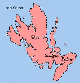
Loch Snizort (Scottish Gaelic: Loch Snìosort) is a sea loch in the northwest of the Isle of Skye between the Waternish and Trotternish peninsulas. It is fed by the River Snizort, originating in the hills east of Bracadale.[1] The mouth of Loch Snizort gives access to the lower Minch and contains the Ascrib Islands.
Sea fishing in Loch Snizort yields mackerel, pollock, and ling.[2]
See also
Footnotes
- ↑ "Loch Snizort". Gazetteer for Scotland. Retrieved 19 September 2009.
- ↑ Bradshaw, Mathew (2007). "Highland Fishing". Archived from the original on 11 January 2012. Retrieved 4 July 2011.
External links
 Media related to Loch Snizort at Wikimedia Commons
57°34′N 6°28′W / 57.567°N 6.467°W
This article is issued from Wikipedia. The text is licensed under Creative Commons - Attribution - Sharealike. Additional terms may apply for the media files.