| Meall Dubh | |
|---|---|
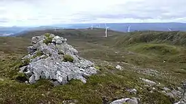 Meall Dubh summit | |
| Highest point | |
| Elevation | 789 m (2,589 ft)[1] |
| Prominence | 544 m (1,785 ft) |
| Listing | Corbett, Marilyn |
| Coordinates | 57°07′41″N 4°54′02″W / 57.1280°N 4.9005°W |
| Geography | |
| Location | Highland, Scotland |
| Parent range | Northwest Highlands |
| OS grid | NH245078 |
| Topo map | OS Landranger 34 |
Meall Dubh (789 m) is a mountain in the Northwest Highlands, Scotland. Lying near the village of Fort Augustus, it is the highest peak between the valleys of Glen Moriston and Glen Garry.
Surrounded by moorland, a wind farm has been constructed on its slopes. The easiest route to the summit of Meall Dubh is from its northern Glen Moriston side[2]
References
- ↑ "Meall Dubh". hill-bagging.co.uk. Retrieved 7 May 2019.
- ↑ "walkhighlands Meall Dubh". walkhighlands.co.uk. Retrieved 7 May 2019.
This article is issued from Wikipedia. The text is licensed under Creative Commons - Attribution - Sharealike. Additional terms may apply for the media files.