Naarn im Machlande | |
|---|---|
 | |
 Coat of arms | |
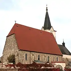
 Naarn im Machlande Location within Austria | |
| Coordinates: 48°13′36″N 14°36′32″E / 48.22667°N 14.60889°E | |
| Country | Austria |
| State | Upper Austria |
| District | Perg |
| Government | |
| • Mayor | Rupert Wahlmüller (SPÖ) |
| Area | |
| • Total | 35.17 km2 (13.58 sq mi) |
| Elevation | 245 m (804 ft) |
| Population (2018-01-01)[2] | |
| • Total | 3,690 |
| • Density | 100/km2 (270/sq mi) |
| Time zone | UTC+1 (CET) |
| • Summer (DST) | UTC+2 (CEST) |
| Postal code | 4331 |
| Area code | 07262 |
| Vehicle registration | PE |
| Website | www.naarn.at |
Naarn im Machlande is a municipality in the district of Perg in the Austrian state of Upper Austria.
Population
| Year | Pop. | ±% |
|---|---|---|
| 1869 | 2,150 | — |
| 1880 | 2,215 | +3.0% |
| 1890 | 2,220 | +0.2% |
| 1900 | 2,275 | +2.5% |
| 1910 | 2,283 | +0.4% |
| 1923 | 2,257 | −1.1% |
| 1934 | 2,368 | +4.9% |
| 1939 | 2,383 | +0.6% |
| 1951 | 2,338 | −1.9% |
| 1961 | 2,440 | +4.4% |
| 1971 | 2,768 | +13.4% |
| 1981 | 2,973 | +7.4% |
| 1991 | 3,077 | +3.5% |
| 2001 | 3,311 | +7.6% |
| 2015 | 3,591 | +8.5% |
References
- ↑ "Dauersiedlungsraum der Gemeinden Politischen Bezirke und Bundesländer - Gebietsstand 1.1.2018". Statistics Austria. Retrieved 10 March 2019.
- ↑ "Einwohnerzahl 1.1.2018 nach Gemeinden mit Status, Gebietsstand 1.1.2018". Statistics Austria. Retrieved 9 March 2019.
Wikimedia Commons has media related to Naarn im Machlande.
This article is issued from Wikipedia. The text is licensed under Creative Commons - Attribution - Sharealike. Additional terms may apply for the media files.