Neshaminy, Pennsylvania | |
|---|---|
Unincorporated community | |
 Neshaminy  Neshaminy | |
| Coordinates: 40°13′46″N 75°08′20″W / 40.22944°N 75.13889°W | |
| Country | United States |
| State | Pennsylvania |
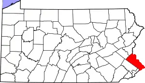
| County | Bucks |
| Township | Warrington |
| Elevation | 253 ft (77 m) |
| Time zone | UTC-5 (Eastern (EST)) |
| • Summer (DST) | UTC-4 (EDT) |
| ZIP Code | 18976 |
| Area code(s) | 215, 267 and 445 |
| GNIS feature ID | 1182257[1] |
Neshaminy is an unincorporated community in Warrington Township in Bucks County, Pennsylvania, United States. Neshaminy is located at the intersection of Pennsylvania Route 611 and Pennsylvania Route 132.[2]
References
- ↑ "Neshaminy". Geographic Names Information System. United States Geological Survey, United States Department of the Interior.
- ↑ Bucks County, Pennsylvania Highway Map (PDF) (Map). PennDOT. 2020. Retrieved March 14, 2021.
This article is issued from Wikipedia. The text is licensed under Creative Commons - Attribution - Sharealike. Additional terms may apply for the media files.