| Ource | |
|---|---|
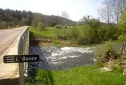 The Ource at Autricourt. | |
 | |
| Location | |
| Country | France |
| Physical characteristics | |
| Source | |
| • location | Near Poinson-lès-Grancey |
| • coordinates | 47°41′24″N 04°58′41″E / 47.69000°N 4.97806°E |
| • elevation | 400 m (1,300 ft) |
| Mouth | |
• location | Seine |
• coordinates | 48°05′46″N 04°22′51″E / 48.09611°N 4.38083°E |
• elevation | 156 m (512 ft) |
| Length | 100 km (62 mi) |
| Basin size | 736 km2 (284 sq mi) |
| Discharge | |
| • average | 8.6 m3/s (300 cu ft/s) |
| Basin features | |
| Progression | Seine→ English Channel |
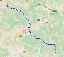
The Ource (French: [uʁs]) is a 100 km (62 mi) long river in northeastern France, a right tributary of the river Seine.[1] Its source is in the Haute-Marne department, 2 km south of Poinson-lès-Grancey. It flows generally northwest. It joins the Seine at Bar-sur-Seine.
Its course crosses the following departments and communes:
References
This article is issued from Wikipedia. The text is licensed under Creative Commons - Attribution - Sharealike. Additional terms may apply for the media files.