Pertlstein | |
|---|---|
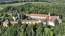 Bertholdstein Castle in Perlstein | |
 Coat of arms | |
 Pertlstein Location within Austria | |
| Coordinates: 46°56′00″N 15°58′00″E / 46.93333°N 15.96667°E | |
| Country | Austria |
| State | Styria |
| District | Südoststeiermark |
| Government | |
| • Mayor | Walter Jansel (ÖVP) |
| Area | |
| • Total | 9.29 km2 (3.59 sq mi) |
| Elevation | 274 m (899 ft) |
| Population (1 January 2016)[1] | |
| • Total | 798 |
| • Density | 86/km2 (220/sq mi) |
| Time zone | UTC+1 (CET) |
| • Summer (DST) | UTC+2 (CEST) |
| Postal code | 8330, 8344, 8350 |
| Area code | +43 3155 |
| Vehicle registration | FB |
| Website | www.pertlstein. steiermark.at |
Pertlstein is a former municipality in the district of Südoststeiermark in the Austrian state of Styria. Since the 2015 Styria municipal structural reform, it is part of the municipality Fehring.[2]
Population
| Year | Pop. | ±% |
|---|---|---|
| 1869 | 573 | — |
| 1880 | 618 | +7.9% |
| 1890 | 608 | −1.6% |
| 1900 | 560 | −7.9% |
| 1910 | 613 | +9.5% |
| 1923 | 683 | +11.4% |
| 1934 | 695 | +1.8% |
| 1939 | 660 | −5.0% |
| 1951 | 651 | −1.4% |
| 1961 | 634 | −2.6% |
| 1971 | 646 | +1.9% |
| 1981 | 713 | +10.4% |
| 1991 | 734 | +2.9% |
| 2001 | 796 | +8.4% |
| 2013 | 797 | +0.1% |
References
This article is issued from Wikipedia. The text is licensed under Creative Commons - Attribution - Sharealike. Additional terms may apply for the media files.