Phúc Yên
Thành phố Phúc Yên | |
|---|---|
| Phúc Yên City | |
 Hồ Đại Lải | |
|
Seal | |
Interactive map outlining Phúc Yên | |
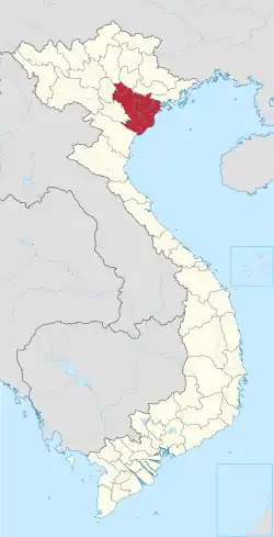
 Phúc Yên Location of Phúc Yên in Vietnam | |
| Coordinates: 21°14′N 105°42′E / 21.233°N 105.700°E | |
| Country | |
| Province | Vĩnh Phúc |
| Capital | Phúc Yên |
| Area | |
| • Total | 120 km2 (50 sq mi) |
| Population (2003) | |
| • Total | 83,352 |
| • Density | 1,295/km2 (3,350/sq mi) |
| Website | phucyen |
Phúc Yên is a city in Vĩnh Phúc Province in the Red River Delta region of Vietnam.[1] As of 2003 the district had a population of 83,352.[2] The district covers an area of 120 km². The district capital lies at Phúc Yên.[2] The city is on National Route 2 heading North-West out of Hanoi to the town of Vĩnh Yên.[3]
References
- ↑ Atlas of the World, Oxford University Press, 2011, p. 226.
- 1 2 "Districts of Vietnam". Statoids. Retrieved March 20, 2009.
- ↑ Tim Doling North East VietNam: mountains and ethnic minorities 2000 Page 52 "Leaving the capital, National Road 2 heads through Phúc Yên to the town of Vĩnh Yên, 53 kilometres north west of Hà Nội."
Districts of the Red River Delta | ||
|---|---|---|
| Hanoi city |
|  |
| Haiphong city | ||
| Bắc Ninh province | ||
| Hà Nam province | ||
| Hải Dương province |
| |
| Hưng Yên province | ||
| Nam Định province | ||
| Ninh Bình province | ||
| Thái Bình province | ||
| Vĩnh Phúc province |
| |
※ denotes provincial seat. | ||
This article is issued from Wikipedia. The text is licensed under Creative Commons - Attribution - Sharealike. Additional terms may apply for the media files.