| Pitten | |
|---|---|
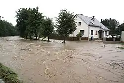 The Pitten in a flood at Pitten | |
| Location | |
| Country | Austria |
| State | Lower Austria |
| Physical characteristics | |
| Source | |
| • location | confluence of the Feistritz and the Großer Pestingbach near Hinterleiten, Feistritz am Wechsel) |
| • coordinates | 47°35′13″N 16°06′00″E / 47.5869°N 16.1001°E |
| Mouth | |
• location | confluence of the Pitten and the Schwarza at Haderswörth in the parish of Lanzenkirchen |
• coordinates | 47°44′06″N 16°13′29″E / 47.7350°N 16.2247°E |
| Basin size | 413 km2 (159 sq mi) |
| Basin features | |
| Progression | Leitha→ Danube→ Black Sea |
The Pitten is a river in Lower Austria. Its basin area is 413 km2 (159 sq mi).[1]
The source of the Pitten is the confluence of its two headstreams Feistritz and Großer Pestingbach, near Hinterleiten, Feistritz am Wechsel.[2] At Haderswörth in the parish of Lanzenkirchen, the Pitten and the Schwarza unite to form the Leitha, a tributary of the Danube.[3]
References
- ↑ "Flächenverzeichnis der Flussgebiete: Leitha-, Rabnitz- und Raabgebiet" (PDF). Beiträge zur Hydrografie Österreichs Heft 63. December 2014. p. 28.
- ↑ Google (20 February 2020). "Pitten origin" (Map). Google Maps. Google. Retrieved 20 February 2020.
- ↑ Google (20 February 2020). "Pitten mouth" (Map). Google Maps. Google. Retrieved 20 February 2020.
This article is issued from Wikipedia. The text is licensed under Creative Commons - Attribution - Sharealike. Additional terms may apply for the media files.