Ried im Oberinntal | |
|---|---|
 | |
 Coat of arms | |
 Ried im Oberinntal Location within Austria | |
| Coordinates: 47°03′19″N 10°39′16″E / 47.05528°N 10.65444°E | |
| Country | Austria |
| State | Tyrol |
| District | Landeck |
| Government | |
| • Mayor | Elmar Handle |
| Area | |
| • Total | 27.45 km2 (10.60 sq mi) |
| Elevation | 876 m (2,874 ft) |
| Population (2018-01-01)[2] | |
| • Total | 1,261 |
| • Density | 46/km2 (120/sq mi) |
| Time zone | UTC+1 (CET) |
| • Summer (DST) | UTC+2 (CEST) |
| Postal code | 6531 |
| Area code | 05472 |
| Vehicle registration | LA |
| Website | http://www.ried-oberinntal.tirol.gv.at |
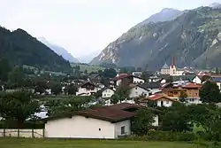
Ried im Oberinntal is a municipality in the district of Landeck in the Austrian state of Tyrol located 12 km south of the city of Landeck and 3 km below Prutz. It was first mentioned in documents in the 12th century. Tourism is the main source of income.
References
- ↑ "Dauersiedlungsraum der Gemeinden Politischen Bezirke und Bundesländer - Gebietsstand 1.1.2018". Statistics Austria. Retrieved 10 March 2019.
- ↑ "Einwohnerzahl 1.1.2018 nach Gemeinden mit Status, Gebietsstand 1.1.2018". Statistics Austria. Retrieved 9 March 2019.
Wikimedia Commons has media related to Ried im Oberinntal.
This article is issued from Wikipedia. The text is licensed under Creative Commons - Attribution - Sharealike. Additional terms may apply for the media files.