Sögtrop | |
|---|---|
 | |
Location of Sögtrop | |
 Sögtrop 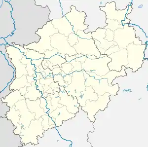 Sögtrop | |
| Coordinates: 51°15′44″N 8°17′18″E / 51.26222°N 8.28833°E | |
| Country | Germany |
| State | North Rhine-Westphalia |
| Admin. region | Arnsberg |
| District | Hochsauerlandkreis |
| Town | Schmallenberg |
| Population (2021-12-31) | |
| • Total | 109 |
| Time zone | UTC+01:00 (CET) |
| • Summer (DST) | UTC+02:00 (CEST) |
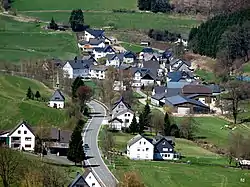
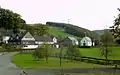
Sögtrop is a locality in the municipality Schmallenberg in the district Hochsauerlandkreis in North Rhine-Westphalia, Germany.
The village has 109 inhabitant[1] and lies in the north of the municipality of Schmallenberg at a height of around 383 m on the Kreisstraße 38. The river Rarbach flows through the village. Sögtrop borders on the villages of Kirchrarbach, Landenbeck, Mönekind and Herhagen.
Sögtrop was first mentioned in 1225 in a document.[2] The village used to belong to the municipality of Rarbach in Amt Fredeburg until the end of 1974.
Gallery
 Sögtrop
 Chapel St. Blasius
References
- ↑ Schmallenberg.de: Inhabitants (in German)
- ↑ Albert K. Hömberg: Geschichtliche Nachrichten über Adelssitze und Rittergüter im Herzogtum Westfalen und ihre Besitzer – Register, von Söchtrop, S. 148, Münster, 2013 (Materialien der Historischen Kommission für Westfalen, PDF-Datei in German)
External links
This article is issued from Wikipedia. The text is licensed under Creative Commons - Attribution - Sharealike. Additional terms may apply for the media files.