Sandamu | |
|---|---|
LGA and town | |
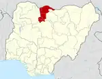
 Sandamu Location in Nigeria | |
| Coordinates: 12°56′N 8°22′E / 12.933°N 8.367°E | |
| Country | |
| State | Katsina State |
| LGA | 1996 |
| Government | |
| • Chairman | sani sabo sandamu |
| Area | |
| • Total | 1,418 km2 (547 sq mi) |
| Population (2006 census) | |
| • Total | 137,287 |
| Time zone | UTC+1 (WAT) |
| 3-digit postal code prefix | 824 |
| ISO 3166 code | NG.KT.SDM |
Sandamu is a Local Government Area in Katsina State, Nigeria. Its headquarters is located in the town of Sandamu on the A2 highway in the north of the area at12°57′37″N 8°21′44″E / 12.96028°N 8.36222°E.
It has an area of 1418 km2 and a population of 137,287 at the 2006 census.
The postal code of the area is 824.[1]
Climatic Condition
The average annual temperature in Sandamu, Nigeria, is 31.49°C, higher than the country's average, with 52.61mm of precipitation and 55.69 days with rain.[2]
There will be colder weather and a warmer climate in Sandamu as a result of the temperature trend brought on by climate change.[3]
References
- ↑ "Post Offices- with map of LGA". NIPOST. Archived from the original on 2012-11-26. Retrieved 2009-10-20.
- ↑ "Sandamu, Katsina, NG Climate Zone, Monthly Averages, Historical Weather Data". tcktcktck.org. Retrieved 2023-08-31.
- ↑ "Climate Change Sandamu". meteoblue. Retrieved 2023-10-21.
External links
State capital: Katsina | ||
| Topics |
|  |
| LGAs | ||
This article is issued from Wikipedia. The text is licensed under Creative Commons - Attribution - Sharealike. Additional terms may apply for the media files.