Seaton
| |
|---|---|
 Seaton Location within Cornwall | |
| OS grid reference | SX304544 |
| Civil parish | |
| Shire county | |
| Region | |
| Country | England |
| Sovereign state | United Kingdom |
| Post town | TORPOINT |
| Postcode district | PL11 |
| Dialling code | 01503 |
| Police | Devon and Cornwall |
| Fire | Cornwall |
| Ambulance | South Western |
| UK Parliament | |
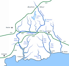
Seaton (Cornish: Sethyn, meaning little arrow after the river) is a village on the south coast of Cornwall, England, at the mouth of the River Seaton 3.8 miles (6.1 km) east of Looe and ten miles (16 km) west of Plymouth.[1] The village is in the civil parish of Deviock.[2]
The village stretches inland along the River Seaton valley.[1] It has two pubs, a beach café. Seaton beach is mostly shingle and stretches from the river to the village of Downderry a mile to the east.
Seaton Valley Countryside Park, one of four Country Parks in Cornwall, is immediately to the north of the village. The park includes a nature trail that can be followed for nearly two miles north to Hessenford.
A Monkey Sanctuary with a colony of woolly monkeys and other rescued primates is two miles to the west.
A station was to be built at Seaton as part of the proposed St Germans & Looe Railway in the late 1930s, but the railway was abandoned without the station having been built.[3]
Gallery
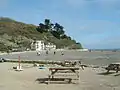 Seaton beach
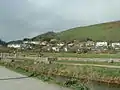 The Seaton valley
 The River Seaton meets the sea
 A minor road west of Seaton
References
- 1 2 Ordnance Survey: Landranger map sheet 201 Plymouth & Launceston ISBN 978-0-319-23146-3
- ↑ Cornwall Council online mapping Archived 2010-05-05 at the Wayback Machine Retrieved June 2010
- ↑ "Bruce Hunt: Proposed line to Looe". Retrieved 10 July 2021.
External links
![]() Media related to Seaton, Cornwall at Wikimedia Commons
Media related to Seaton, Cornwall at Wikimedia Commons
| Unitary authorities | |
|---|---|
| Major settlements (cities in italics) |
|
| Rivers | |
| Topics | |