| Shilka | |
|---|---|
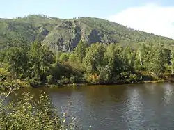 The Shilka River near Bolotovo. | |
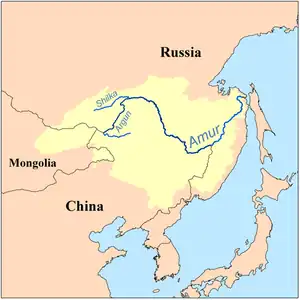 Location of the Shilka River within the Amur Basin | |
| Location | |
| Country | Russia |
| Physical characteristics | |
| Mouth | Amur |
• coordinates | 53°19′58″N 121°28′49″E / 53.33278°N 121.48028°E |
| Length | 560 km (350 mi) |
| Basin size | 206,000 km2 (80,000 sq mi) |
| Discharge | |
| • average | 440 m3/s (16,000 cu ft/s) |
| Basin features | |
| Progression | Amur→ Sea of Okhotsk |
_p067_THE_S.S._AMUR_ON_THE_SHILKA_RIVER_(14780102424).jpg.webp)
The S.S. AMUR on the Shilka River (c.1902)
The Shilka (Russian: Ши́лка; Evenki: Силькари, Sil'kari; Buryat: Шилкэ, Shilke; Mongolian: Шилка, Shilka; Chinese: 石勒喀) is a river in Zabaykalsky Krai, (Dauria) south-eastern Russia. It has a length of 560 km (350 mi), and has a drainage basin of 206,000 square kilometres (80,000 sq mi).[1]
Course
It originates as the confluence of the rivers Onon and Ingoda. Its confluence with the Argun on the Russia-China border gives rise to the Amur. The river is navigable for its entire length. The town Sretensk lies on the Shilka.[1]
Tributaries
The largest tributaries of the Shilka are, from source to mouth:[3]
See also
References
- 1 2 Шилка (река), Great Soviet Encyclopedia
- ↑ E.M. Pospelov, Geograficheskie nazvaniya mira (Moscow: Russkie slovari, 1998), p. 473.
- ↑ "Река ШИЛКА in the State Water Register of Russia". textual.ru (in Russian).
This article is issued from Wikipedia. The text is licensed under Creative Commons - Attribution - Sharealike. Additional terms may apply for the media files.