| Solnan | |
|---|---|
_RKJ_P7286554.jpg.webp) | |
 | |
| Location | |
| Country | France |
| Physical characteristics | |
| Source | |
| • location | Verjon |
| • coordinates | 46°20′33″N 05°21′34″E / 46.34250°N 5.35944°E |
| • elevation | 235 m (771 ft) |
| Mouth | |
• location | Seille |
• coordinates | 46°37′45″N 05°13′05″E / 46.62917°N 5.21806°E |
• elevation | 177 m (581 ft) |
| Length | 61.6 km (38.3 mi) |
| Basin size | 680 km2 (260 sq mi) |
| Discharge | |
| • average | 13 m3/s (460 cu ft/s) |
| Basin features | |
| Progression | Seille→ Saône→ Rhône→ Mediterranean Sea |
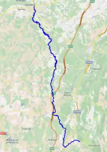
The Solnan (French pronunciation: [sɔlnɑ̃]) is a 61.6-kilometre (38.3 mi) long river in the Ain and Saône-et-Loire departments in eastern France.[1] Its source is at Verjon, in the Jura Mountains. It flows generally north-northwest. It is a left tributary of the Seille into which it flows at Louhans.
Departments and communes along its course
This list is ordered from source to mouth:
- Ain: Verjon, Villemotier, Bény, Salavre, Coligny, Pirajoux, Domsure, Beaupont,
- Saône-et-Loire: Condal, Dommartin-lès-Cuiseaux, Varennes-Saint-Sauveur, Frontenaud, Sainte-Croix, Bruailles, La Chapelle-Naude, Louhans,
References
This article is issued from Wikipedia. The text is licensed under Creative Commons - Attribution - Sharealike. Additional terms may apply for the media files.