Sourcieux-les-Mines | |
|---|---|
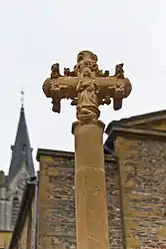 Monumental cross of the 15th century, historical monument since 1926, in front of the church | |
.svg.png.webp) Coat of arms | |
Location of Sourcieux-les-Mines | |
 Sourcieux-les-Mines 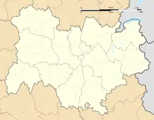 Sourcieux-les-Mines | |
| Coordinates: 45°48′25″N 4°37′24″E / 45.8069°N 4.6233°E | |
| Country | France |
| Region | Auvergne-Rhône-Alpes |
| Department | Rhône |
| Arrondissement | Villefranche-sur-Saône |
| Canton | L'Arbresle |
| Intercommunality | Pays de L'Arbresle |
| Government | |
| • Mayor (2020–2026) | Guillaume Arnold[1] |
| Area 1 | 9.96 km2 (3.85 sq mi) |
| Population | 2,094 |
| • Density | 210/km2 (540/sq mi) |
| Time zone | UTC+01:00 (CET) |
| • Summer (DST) | UTC+02:00 (CEST) |
| INSEE/Postal code | 69177 /69210 |
| Elevation | 260–660 m (850–2,170 ft) (avg. 400 m or 1,300 ft) |
| 1 French Land Register data, which excludes lakes, ponds, glaciers > 1 km2 (0.386 sq mi or 247 acres) and river estuaries. | |
Sourcieux-les-Mines (French pronunciation: [suʁsjø le min] ⓘ) is a commune in the Rhône department in eastern France.
Population
| Year | Pop. | ±% p.a. |
|---|---|---|
| 1968 | 794 | — |
| 1975 | 834 | +0.70% |
| 1982 | 1,156 | +4.77% |
| 1990 | 1,349 | +1.95% |
| 1999 | 1,762 | +3.01% |
| 2007 | 1,887 | +0.86% |
| 2012 | 1,963 | +0.79% |
| 2017 | 2,029 | +0.66% |
| Source: INSEE[3] | ||
See also
References
- ↑ "Répertoire national des élus: les maires". data.gouv.fr, Plateforme ouverte des données publiques françaises (in French). 2 December 2020.
- ↑ "Populations légales 2021". The National Institute of Statistics and Economic Studies. 28 December 2023.
- ↑ Population en historique depuis 1968, INSEE
Wikimedia Commons has media related to Sourcieux-les-Mines.
This article is issued from Wikipedia. The text is licensed under Creative Commons - Attribution - Sharealike. Additional terms may apply for the media files.