| Stretton Grandison | |
|---|---|
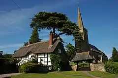 St Lawrence's Church | |
 Stretton Grandison Location within Herefordshire | |
| Population | 175 (2011 Census) |
| Unitary authority | |
| Shire county | |
| Region | |
| Country | England |
| Sovereign state | United Kingdom |
| Post town | Ledbury |
| Postcode district | HR8 |
| Police | West Mercia |
| Fire | Hereford and Worcester |
| Ambulance | West Midlands |
| UK Parliament | |
Stretton Grandison is a hamlet and small civil parish in Herefordshire, England. The population of the civil parish at the 2011 census was 175.[1]
It is on the A417 road (a Roman Road, hence the settlement's name "Stretton") to the north-east of Hereford.[2] The River Frome flows along the parish's southern boundary.
The Church of St Lawrence, dating from its 14th-century rebuilding of an earlier church, is a Grade I listed building.[3]
References
- ↑ "Stretton Grandison (Parish, United Kingdom) - Population Statistics, Charts, Map and Location". www.citypopulation.de. Retrieved 1 May 2020.
- ↑ Ordnance Survey mapping
- ↑ "Church of St Lawrence, Stretton Grandison". British Listed Buildings. Retrieved 30 January 2014.
External links
 Media related to Stretton Grandison at Wikimedia Commons
52°05′N 2°32′W / 52.09°N 2.54°W
This article is issued from Wikipedia. The text is licensed under Creative Commons - Attribution - Sharealike. Additional terms may apply for the media files.