Weichselbaum | |
|---|---|
 | |
 Coat of arms | |
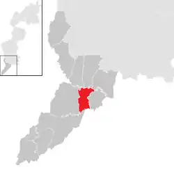 Location within Jennersdorf district | |
 Weichselbaum Location within Austria | |
| Coordinates: 46°57′N 16°11′E / 46.950°N 16.183°E | |
| Country | Austria |
| State | Burgenland |
| District | Jennersdorf |
| Government | |
| • Mayor | Harald Brunner (ÖVP) |
| Area | |
| • Total | 12.17 km2 (4.70 sq mi) |
| Elevation | 239 m (784 ft) |
| Population (2018-01-01)[2] | |
| • Total | 720 |
| • Density | 59/km2 (150/sq mi) |
| Time zone | UTC+1 (CET) |
| • Summer (DST) | UTC+2 (CEST) |
| Postal code | 8382 |
| Area code | +43 3329 |
| Website | http://www.gemeinde-weichselbaum.at/ |
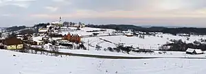
Weichselbaum (Hungarian: Badafalva, Slovene: Badavci) is a town in the district of Jennersdorf in the Austrian state of Burgenland.
Geography
Cadastral communities are Krobotek, Rosendorf and Weichselbaum.[3]
Toponymy
Weichselbaum is a common surname in Austria. The meaning of Weichselbaum in the English language is sour cherry tree.
Population
| Year | Pop. | ±% |
|---|---|---|
| 1869 | 1,388 | — |
| 1880 | 1,536 | +10.7% |
| 1890 | 1,597 | +4.0% |
| 1900 | 1,640 | +2.7% |
| 1910 | 1,639 | −0.1% |
| 1923 | 1,407 | −14.2% |
| 1934 | 1,299 | −7.7% |
| 1939 | 1,306 | +0.5% |
| 1951 | 1,190 | −8.9% |
| 1961 | 1,111 | −6.6% |
| 1971 | 1,047 | −5.8% |
| 1981 | 983 | −6.1% |
| 1991 | 884 | −10.1% |
| 2001 | 796 | −10.0% |
| 2011 | 732 | −8.0% |
| 2016 | 729 | −0.4% |
References
- ↑ "Dauersiedlungsraum der Gemeinden Politischen Bezirke und Bundesländer - Gebietsstand 1.1.2018". Statistics Austria. Retrieved 10 March 2019.
- ↑ "Einwohnerzahl 1.1.2018 nach Gemeinden mit Status, Gebietsstand 1.1.2018". Statistics Austria. Retrieved 9 March 2019.
- ↑ Katastralgemeindenverzeichnis, www.bev.gv.at
This article is issued from Wikipedia. The text is licensed under Creative Commons - Attribution - Sharealike. Additional terms may apply for the media files.