Meillard | |
|---|---|
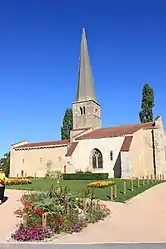 The church in Meillard | |
Location of Meillard | |
 Meillard 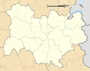 Meillard | |
| Coordinates: 46°23′24″N 3°14′08″E / 46.39°N 3.2356°E | |
| Country | France |
| Region | Auvergne-Rhône-Alpes |
| Department | Allier |
| Arrondissement | Moulins |
| Canton | Souvigny |
| Intercommunality | Bocage Bourbonnais |
| Government | |
| • Mayor (2020–2026) | Yves Simon[1] |
| Area 1 | 25.48 km2 (9.84 sq mi) |
| Population | 315 |
| • Density | 12/km2 (32/sq mi) |
| Time zone | UTC+01:00 (CET) |
| • Summer (DST) | UTC+02:00 (CEST) |
| INSEE/Postal code | 03169 /03500 |
| Elevation | 245–391 m (804–1,283 ft) (avg. 375 m or 1,230 ft) |
| 1 French Land Register data, which excludes lakes, ponds, glaciers > 1 km2 (0.386 sq mi or 247 acres) and river estuaries. | |
Meillard (French pronunciation: [mɛjaʁ]) is a commune in the Allier department in central France.[3]
Population
| Year | Pop. | ±% |
|---|---|---|
| 1962 | 304 | — |
| 1968 | 342 | +12.5% |
| 1975 | 340 | −0.6% |
| 1982 | 300 | −11.8% |
| 1990 | 280 | −6.7% |
| 1999 | 280 | +0.0% |
| 2008 | 244 | −12.9% |
| 2012 | 299 | +22.5% |
| Source: INSEE (1968–2012) | ||
See also
References
- ↑ "Répertoire national des élus: les maires" (in French). data.gouv.fr, Plateforme ouverte des données publiques françaises. 13 September 2022.
- ↑ "Populations légales 2021". The National Institute of Statistics and Economic Studies. 28 December 2023.
- ↑ INSEE commune file
Wikimedia Commons has media related to Meillard.
This article is issued from Wikipedia. The text is licensed under Creative Commons - Attribution - Sharealike. Additional terms may apply for the media files.