Route 204 | ||||
|---|---|---|---|---|
 | ||||
| Route information | ||||
| Maintained by Transports Québec | ||||
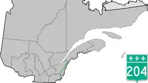
| Length | 263.9 km[1] (164.0 mi) | |||
| Major junctions | ||||
| West end | ||||
| East end | ||||
| Location | ||||
| Country | Canada | |||
| Province | Quebec | |||
| Highway system | ||||
| ||||

Route 204 is a finite two-lane east/west highway on the south shore of the Saint Lawrence River in Quebec. It is one of the longest secondary highways in the province. Its eastern terminus is in Saint-Jean-Port-Joli at the junction of Route 132 and the western terminus is in Lac-Mégantic at the junction of Route 161. Although it is numbered as an east/west highway, the road follows a north/south course from Saint-Jean-Port-Joli to Saint-Pamphile, where it then follows a mostly southwest/northeast course until Saint-Georges, where after crossing the Chaudière River, follows it in a north/south course until the source of the Chaudiere in Megantic Lake, in Lac-Mégantic.
Municipalities along Route 204
- Lac-Mégantic
- Frontenac
- Audet
- Saint-Ludger
- Saint-Gédéon-de-Beauce
- Saint-Martin
- Saint-Georges
- Saint-Prosper
- Sainte-Rose-de-Watford
- Sainte-Justine
- Saint-Camille-de-Lellis
- Saint-Just-de-Bretenières
- Saint-Fabien-de-Panet
- Sainte-Lucie-de-Beauregard
- Saint-Adalbert
- Saint-Pamphile
- Sainte-Perpétue
- Tourville
- Saint-Damase-de-L'Islet
- Saint-Aubert
- Saint-Jean-Port-Joli
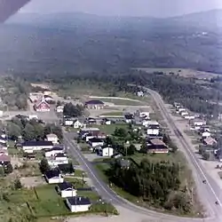 Route 204 bypasses Frontenac.
 Route 204 in Saint-Martin, near route 269.
 Downtown Saint-Georges with, in the background, Lacroix boulevard (routes 173 and 204) that bypasses it.
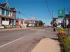 Route 204 in Saint-Camille.
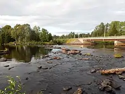 Bridge over Saint John River in Lac-Frontière.
.jpg.webp) Route 204 leaving Tourville.
Route 204 leaving Tourville..jpg.webp) Bridge over Trois-Saumons river in Saint-Damase.
Bridge over Trois-Saumons river in Saint-Damase.
Major intersections
| RCM or ET | Municipality | Km | Junction | Notes |
|---|---|---|---|---|
Western terminus of Route 204 | ||||
| Le Granit | Lac-Mégantic | 0.0 | 161 SOUTH: to Frontenac 161 NORTH: to Nantes | |
| Audet | 21.1 | Chemin-du-Lac-Drolet | NORTH: to Lac-Drolet | |
| Saint-Ludger | 39.1 | 9e Rang | SOUTH: to Saint-Robert-Bellarmin | |
| Beauce-Sartigan | Saint-Gédéon-de-Beauce | 48.8 | 269 SOUTH: to Saint-Théophile | |
| Saint-Martin | 57.7 | 269 NORTH: to Saint-Honoré-de-Shenley | ||
| Saint-Georges | 74.0 | 173 SOUTH: to Saint-Côme–Linière | ||
| 77.2 | 271 NORTH: to Saint-Benoît-Labre | |||
| 78.4 | 173 NORTH: to Notre-Dame-des-Pins | |||
| 73 NORTH: to Notre-Dame-des-Pins | ||||
| Les Etchemins | Saint-Prosper | 96.9 | 275 SOUTH: to Sainte-Aurélie 275 NORTH: to Saint-Benjamin | |
| Sainte-Rose-de-Watford | 112.3 117.4 |
277 SOUTH: to Saint-Louis-de-Gonzague 277 NORTH: to Lac-Etchemin | ||
| Sainte-Justine | 125.3 | Route des Eglises | SOUTH: to Saint-Cyprien | |
| Saint-Camille-de-Lellis | 141.9 | 281 NORTH: to Saint-Magloire | ||
| Montmagny | Saint-Just-de-Bretinieres | 155.2 | 283 SOUTH: to Lac-Frontière | |
| Saint-Fabien-de-Panet | 159.3 | 283 NORTH: to Saint-Paul-de-Montminy | ||
| Sainte-Lucie-de-Beauregard | 169.3 | 283 NORTH: to Lac-Frontière | ||
| L'Islet | Saint-Adalbert | 189.7 | 285 NORTH: to Saint-Marcel | |
| Sainte-Perpetue | 221.7 | 216 WEST: to Sainte-Félicité | ||
| Saint-Jean-Port-Joli | 260.7 261.2 |
20 EAST: to Saint-Roch-des-Aulnaies 20 WEST: to L'Islet | ||
| 263.9 | 132 WEST: to L'Islet 132 EAST: to Saint-Roch-des-Aulnaies | |||
Eastern terminus of Route 204 | ||||
See also
References
- ↑ Ministère des transports, "Distances routières", page 80, Les Publications du Québec, 2005
External links
- Provincial Route Map (Courtesy of the Quebec Ministry of Transportation) (in French)
- Route 204 on Google Maps
This article is issued from Wikipedia. The text is licensed under Creative Commons - Attribution - Sharealike. Additional terms may apply for the media files.