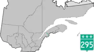
Route 295 | ||||
|---|---|---|---|---|
 | ||||
| Route information | ||||
| Length | 98 km[1] (61 mi) | |||
| Major junctions | ||||
| North end | ||||
| South end | ||||
| Location | ||||
| Country | Canada | |||
| Province | Quebec | |||
| Major cities | Degelis | |||
| Highway system | ||||
| ||||

Route 295 is a 98 km two-lane north–south highway in Quebec, Canada, which starts in Saint-Jean-de-Dieu at the junction of Route 293 and ends in Dégelis at the junction of Autoroute 85.
List of towns along Route 295
- Saint-Jean-de-Dieu
- Sainte-Rita
- Saint-Guy
- Squatec
- Saint-Michel-du-Squatec
- Lejeune
- Auclair
- Lots Renverses
- Degelis
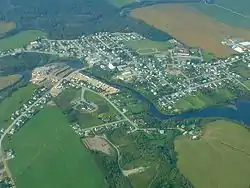 Route 295 passes through Saint-Michel-du-Squatec.
 Advance sign for Route 295 junction in Sainte-Rita.
See also
References
- ↑ Ministère des transports, "Distances routières", page (?), Les Publications du Québec, 2005
External links
- Provincial Route Map (Courtesy of the Quebec Ministry of Transportation) (in French)
- Route 295 on Google Maps
This article is issued from Wikipedia. The text is licensed under Creative Commons - Attribution - Sharealike. Additional terms may apply for the media files.