Rainbach im Mühlkreis | |
|---|---|
 | |
 Coat of arms | |
 Rainbach im Mühlkreis Location within Austria | |
| Coordinates: 48°33′40″N 14°28′40″E / 48.56111°N 14.47778°E | |
| Country | Austria |
| State | Upper Austria |
| District | Freistadt |
| Government | |
| • Mayor | Friedrich Stockinger (ÖVP) |
| Area | |
| • Total | 49.09 km2 (18.95 sq mi) |
| Elevation | 719 m (2,359 ft) |
| Population (2018-01-01)[2] | |
| • Total | 2,959 |
| • Density | 60/km2 (160/sq mi) |
| Time zone | UTC+1 (CET) |
| • Summer (DST) | UTC+2 (CEST) |
| Postal code | 4261 |
| Area code | 07949 |
| Vehicle registration | FR |
| Website | www.rainbach-mkr.at |
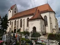
Rainbach im Mühlkreis is a municipality in the district of Freistadt in the Austrian state of Upper Austria.
Population
| Year | Pop. | ±% |
|---|---|---|
| 1869 | 2,335 | — |
| 1880 | 2,501 | +7.1% |
| 1890 | 2,386 | −4.6% |
| 1900 | 2,381 | −0.2% |
| 1910 | 2,491 | +4.6% |
| 1923 | 2,634 | +5.7% |
| 1934 | 2,617 | −0.6% |
| 1939 | 2,602 | −0.6% |
| 1951 | 2,759 | +6.0% |
| 1961 | 2,729 | −1.1% |
| 1971 | 2,776 | +1.7% |
| 1981 | 2,763 | −0.5% |
| 1991 | 2,881 | +4.3% |
| 2001 | 2,934 | +1.8% |
References
- ↑ "Dauersiedlungsraum der Gemeinden Politischen Bezirke und Bundesländer - Gebietsstand 1.1.2018". Statistics Austria. Retrieved 10 March 2019.
- ↑ "Einwohnerzahl 1.1.2018 nach Gemeinden mit Status, Gebietsstand 1.1.2018". Statistics Austria. Retrieved 9 March 2019.
Wikimedia Commons has media related to Rainbach im Mühlkreis.
This article is issued from Wikipedia. The text is licensed under Creative Commons - Attribution - Sharealike. Additional terms may apply for the media files.