Sankt Martin im Mühlkreis | |
|---|---|
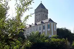 Neuhaus castle | |
 Coat of arms | |
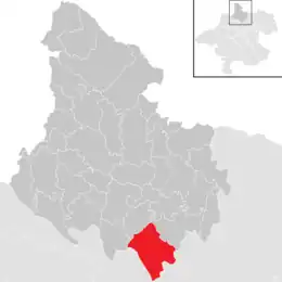 Location in the district | |
 Sankt Martin im Mühlkreis Location within Austria | |
| Coordinates: 48°25′00″N 14°02′21″E / 48.41667°N 14.03917°E | |
| Country | Austria |
| State | Upper Austria |
| District | Rohrbach |
| Government | |
| • Mayor | Wolfgang Schirz (ÖVP) |
| Area | |
| • Total | 34.85 km2 (13.46 sq mi) |
| Elevation | 549 m (1,801 ft) |
| Population (2018-01-01)[2] | |
| • Total | 3,757 |
| • Density | 110/km2 (280/sq mi) |
| Time zone | UTC+1 (CET) |
| • Summer (DST) | UTC+2 (CEST) |
| Postal code | 4113 |
| Area code | 07232 |
| Vehicle registration | RO |
| Website | www.sankt-martin.at |
Sankt Martin im Mühlkreis is a municipality in the district of Rohrbach in the Austrian state of Upper Austria.
Population
| Year | Pop. | ±% |
|---|---|---|
| 1869 | 2,068 | — |
| 1880 | 2,109 | +2.0% |
| 1890 | 2,197 | +4.2% |
| 1900 | 2,201 | +0.2% |
| 1910 | 2,314 | +5.1% |
| 1923 | 2,251 | −2.7% |
| 1934 | 2,301 | +2.2% |
| 1939 | 2,198 | −4.5% |
| 1951 | 2,094 | −4.7% |
| 1961 | 2,197 | +4.9% |
| 1971 | 2,359 | +7.4% |
| 1981 | 2,725 | +15.5% |
| 1991 | 3,239 | +18.9% |
| 2001 | 3,588 | +10.8% |
| 2011 | 3,612 | +0.7% |
| 2017 | 3,776 | +4.5% |
References
- ↑ "Dauersiedlungsraum der Gemeinden Politischen Bezirke und Bundesländer - Gebietsstand 1.1.2018". Statistics Austria. Retrieved 10 March 2019.
- ↑ "Einwohnerzahl 1.1.2018 nach Gemeinden mit Status, Gebietsstand 1.1.2018". Statistics Austria. Retrieved 9 March 2019.
Wikimedia Commons has media related to Sankt Martin im Mühlkreis.
This article is issued from Wikipedia. The text is licensed under Creative Commons - Attribution - Sharealike. Additional terms may apply for the media files.