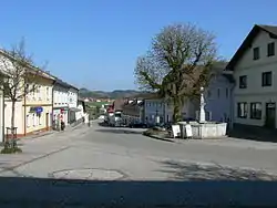
Sankt Peter am Wimberg | |
|---|---|
 | |
 Coat of arms | |
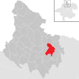 Location in the district | |
 Sankt Peter am Wimberg Location within Austria | |
| Coordinates: 48°30′10″N 14°05′12″E / 48.50278°N 14.08667°E | |
| Country | Austria |
| State | Upper Austria |
| District | Rohrbach |
| Government | |
| • Mayor | Engelbert Pichler (ÖVP) |
| Area | |
| • Total | 23.35 km2 (9.02 sq mi) |
| Elevation | 668 m (2,192 ft) |
| Population (2018-01-01)[2] | |
| • Total | 1,770 |
| • Density | 76/km2 (200/sq mi) |
| Time zone | UTC+1 (CET) |
| • Summer (DST) | UTC+2 (CEST) |
| Postal code | 4171 |
| Area code | 07282 |
| Vehicle registration | RO |
| Website | www.st-peter-wimberg.ooe.gv.at |
Sankt Peter am Wimberg is a municipality in the district of Rohrbach in the Austrian state of Upper Austria. It is located 173 km from Austria's capital city, Vienna.[3] The municipality also observes Daylight saving time (DST).[3]
Geography
Sankt Peter am Wimberg lies in the upper Mühlviertel. About 28 percent of the municipality is forest, and 66 percent is farmland.
References
- ↑ "Dauersiedlungsraum der Gemeinden Politischen Bezirke und Bundesländer - Gebietsstand 1.1.2018". Statistics Austria. Retrieved 10 March 2019.
- ↑ "Einwohnerzahl 1.1.2018 nach Gemeinden mit Status, Gebietsstand 1.1.2018". Statistics Austria. Retrieved 9 March 2019.
- 1 2 "Sankt Peter am Wimberg, Upper Austria, Austria - City, Town and Village of the world". en.db-city.com. Retrieved 2018-05-21.
Wikimedia Commons has media related to St. Peter am Wimberg.
This article is issued from Wikipedia. The text is licensed under Creative Commons - Attribution - Sharealike. Additional terms may apply for the media files.