Marignieu | |
|---|---|
Commune | |
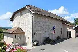 Town hall | |
Location of Marignieu | |
 Marignieu 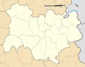 Marignieu | |
| Coordinates: 45°47′52″N 5°43′19″E / 45.7978°N 5.7219°E | |
| Country | France |
| Region | Auvergne-Rhône-Alpes |
| Department | Ain |
| Arrondissement | Belley |
| Canton | Belley |
| Government | |
| • Mayor (2020–2026) | Pascal Demange[1] |
| Area 1 | 3.55 km2 (1.37 sq mi) |
| Population | 167 |
| • Density | 47/km2 (120/sq mi) |
| Time zone | UTC+01:00 (CET) |
| • Summer (DST) | UTC+02:00 (CEST) |
| INSEE/Postal code | 01234 /01300 |
| Elevation | 309–503 m (1,014–1,650 ft) (avg. 358 m or 1,175 ft) |
| 1 French Land Register data, which excludes lakes, ponds, glaciers > 1 km2 (0.386 sq mi or 247 acres) and river estuaries. | |
Marignieu (French pronunciation: [maʁiɲø]) is a commune in the Ain department in eastern France.
Population
| Year | Pop. | ±% p.a. |
|---|---|---|
| 1968 | 114 | — |
| 1975 | 127 | +1.55% |
| 1982 | 141 | +1.51% |
| 1990 | 138 | −0.27% |
| 1999 | 156 | +1.37% |
| 2009 | 151 | −0.33% |
| 2014 | 172 | +2.64% |
| 2020 | 167 | −0.49% |
| Source: INSEE[3] | ||
See also
References
- ↑ "Répertoire national des élus: les maires". data.gouv.fr, Plateforme ouverte des données publiques françaises (in French). 2 December 2020.
- ↑ "Populations légales 2021". The National Institute of Statistics and Economic Studies. 28 December 2023.
- ↑ Population en historique depuis 1968, INSEE
Wikimedia Commons has media related to Marignieu.
This article is issued from Wikipedia. The text is licensed under Creative Commons - Attribution - Sharealike. Additional terms may apply for the media files.